California doesn't just have to worry about earthquakes:
Like many Californians, Jeffrey Mount, a geologist, has done a lot of thinking about water.
He grew up in Los Angeles and remembers trying to save neighbors' homes with sandbags during winter floods in 1969. As a young professor at the University of California, Davis, he watched a severe 1986 storm inundate Yuba City and Marysville.
"The surface of the earth is shaped by flood events," Dr. Mount, 51, said in an interview at this year's meeting of the American Association for the Advancement of Science in St. Louis. "However, it's mighty inconvenient when that water comes rushing through your backyard."
Avoidance of such calamities has been a central focus for Dr. Mount. In 1995, the University of the California Press published a textbook highly critical of river management practices in his state. Five years later, Dr. Mount became a maverick member of California State Reclamation Board, which oversees parts of the state levee system.
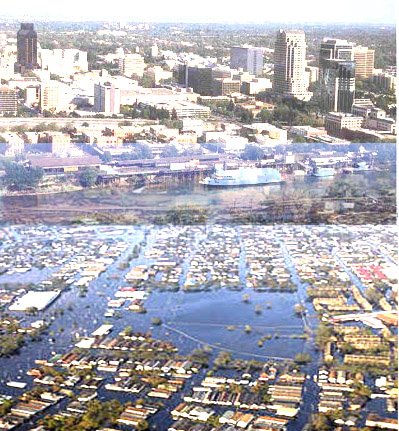
Last fall, after Dr. Mount publicly suggested that the city of Sacramento might be vulnerable to a Hurricane Katrina-like disaster, Gov. Arnold Schwarzenegger dismissed all the board members, Dr. Mount said. None had been appointed by him.
Appointments "are at the pleasure of the governor," said Sabrina Demayo Lockhart, deputy press secretary for the governor, adding that he had named "a wide variety of individuals who have extensive knowledge about California's water management."
Q. If you were making a bet, where would you say the next New Orleans will be?
A. I'd say the Sacramento area. The common denominator is concentrated urban development in the shadow of flooding and levees.
You have around 400,000 people at risk from flooding, and the number will grow in the next few years because of intense development.
The city's main problem is that it is situated between the American and the Sacramento Rivers and at the base of the 12,000 foot Sierra Nevada range. Both rivers are prone to flooding. Additionally, powerful storms come in from the Pacific, slam against the mountains and dump heavy precipitation that ends up very quickly in the rivers.
Yet, around Sacramento — the capital of the seventh largest economy in the world — there's intense building on the flood plains.
Twenty miles downstream is the Sacramento-San Joaquin Delta, a maze of leveed islands and channels that flow into San Francisco Bay. Because of past agricultural practices, the delta is sinking. Parts are 20 feet below sea level, lower than anything in New Orleans. Still, there are proposals to put up 130,000 new homes in the delta.
Q. Why is there so much development in risky places?
A. Because the new gold rush in California is real estate. Moreover, local governments are often reluctant to exert controls over developers because of the tax revolution.
Do you remember Proposition 13 in 1978, which limited increases in property taxes on existing homes? It decimated the ability of localities to fund services. So money for basic services that people expect is now raised through growth.
Many municipalities have become very aggressive about development. I heard a Northern California county supervisor say that his county needed development on its flood plain to fund flood control projects.
Q. New Orleans was inundated after its levee system was breached by floodwaters. How strong are the levees around Sacramento?
A. They offer a very low level of flood protection, probably the lowest for any major metropolitan area in the country. That assessment comes from the Army Corps of Engineers.
The New Orleans levees were rated as having a 200-year level of flood protection. That's a 1 in 200 chance that the levees will be overwhelmed in a given year. Sacramento's levees are rated at less than half of that.
Will Sifu recommend abandonment?
No comments:
Post a Comment